Europe Map-Understanding the Geographic and Political Regions of Europe
Europe Map-Understanding the Geographic and Political Regions of Europe
Introduction to Europe’s Geographic Diversity
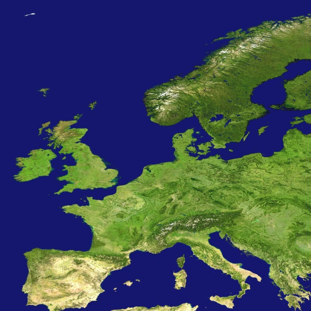
Europe, often regarded as a tapestry of diverse landscapes and cultures, offers a complex geographic profile which can be effectively illustrated by a detailed europe map. This continent showcases a remarkable variety of physical environments ranging from the towering Alps in the central regions to the serene beaches along the Mediterranean coastline. Each geographical feature contributes significantly to the ecological and climatic variations experienced across Europe, ultimately shaping the way of life for its inhabitants.
The continent consists of various ecological regions, such as temperate forests, tundra, and steppe ecosystems, which can be readily visualized on an europe map. These diverse environments are not just a product of geography; they influence agricultural practices, economic activities, and local culinary traditions. For instance, countries like France and Italy benefit from their temperate climate, which allows for the flourishing of vineyards, while Scandinavia’s colder climate supports a different range of agricultural products and industries.
In addition to physical landscapes, the climate of Europe plays a crucial role in determining cultural practices and historical developments. The region’s climatic diversity ranges from the mild, wet climates of Western Europe to the harsher, continental climates found in Eastern Europe. Such differences foster unique adaptations in lifestyle, architecture, and social customs, further enriching Europe’s cultural mosaic.
Understanding this geographic diversity is essential not only for geographical education but also for appreciating how interconnected the natural environment and human cultures are. The layers of history that unfold across the continent reflect the interactions between its diverse geographical regions, as depicted on an europe map, highlighting the continent’s role as a hub of historical and cultural exchanges.
Overview of Political Groupings in Europe
Europe’s political landscape is characterized by a complex web of alliances and treaties that shape the continent’s relations and interactions. At the forefront of these political groupings is the European Union (EU), a unique supranational entity that facilitates economic and political integration among its member states. Established with the goal of fostering peace, stability, and prosperity, the EU has expanded significantly since its inception, now comprising 27 member countries. The Europe map reflects not only geographical boundaries but also the political affiliations that guide these nations’ policies and governance structures.
A significant aspect of the EU’s influence lies in its ability to harmonize laws and regulations across member countries, impacting diverse sectors such as trade, environmental protection, and consumer rights. Additionally, the EU serves as a platform for collaborative initiatives that address common challenges, from climate change to security threats. This close-knit relationship among countries allows for a united stance on various international matters.
In parallel to the EU, NATO (North Atlantic Treaty Organization) plays a crucial role in Europe’s political dynamics. Composed of 30 member states, NATO focuses primarily on military cooperation and collective defense. The organization was established to counterbalance the threat posed during the Cold War and has since adapted to address modern-day crises including terrorism and cyber threats. The presence of NATO in the Europe map illustrates the military alliances that remain essential for ensuring territorial integrity and national security.
In addition to these major entities, there are other significant political groupings that influence the regional landscape. The Council of Europe, the Organization for Security and Co-operation in Europe (OSCE), and the Commonwealth of Independent States (CIS) contribute to the intricate fabric of political relationships within Europe. These organizations facilitate dialogue and cooperation among nations, further enhancing the interconnectedness depicted in any accurate Europe map.
Western Europe: Major Economies and Influence
Western Europe comprises several key nations that play a vital role in the continent’s economy, culture, and political landscape. This region is characterized not only by its rich history but also by the significant impact it has on European identity. The countries of France, Germany, Austria, Belgium, the Netherlands, and Switzerland are central to this analysis.
France, often recognized for its pivotal position in European politics, is one of the largest economies in the region. The europe map illustrates France’s extensive borders and its influence across the continent. With a diverse economy ranging from agriculture to technology, France is a crucial player in trade and international relations.
Germany stands as the leading economic powerhouse of Western Europe, known for its engineering, manufacturing, and export capabilities. As depicted in the europe map, Germany not only supports its own economy but also positively affects other nations through alliances and partnerships within the European Union. The country’s commitment to renewable energy and innovation further highlights its significance in addressing contemporary challenges.
Austria, though smaller in size, has a strong economy that benefits from its strategic location in central Europe. The nation serves as a hub for business and trade, fostering connections with both Eastern and Western Europe. Belgium and the Netherlands are equally important, with their economies thriving on trade, logistics, and services. The ports of Antwerp and Rotterdam are among the busiest in the world, enhancing their roles as gateways for international commerce.
Switzerland, renowned for its stability and high standard of living, adds to the region’s economic fabric with banking, finance, and high-tech industries. Its neutrality and diplomatic policies also contribute to its enduring influence across Europe.
Historically, Western Europe has been a center of cultural development, shaping the arts, philosophy, and democratic ideals. The rich cultural heritage that flows through these countries remains a cornerstone of European identity today. Each nation contributes distinct customs and traditions, underscoring the importance of diversity in unity.
Through its strong economies and cultural significance, Western Europe continues to shape the landscape of the continent, illustrating the interconnectedness depicted in the europe map and emphasizing its integral role in fostering a collective European identity.
Northern Europe: The Nordic Nations and Their Role
Northern Europe is known for its distinctive geography and rich cultural heritage, encompassing the United Kingdom, the Republic of Ireland, and the Nordic countries, including Denmark, Norway, Sweden, Finland, and Iceland. These regions collectively contribute to a unique cultural tapestry that highlights their individual identities and shared history.
Starting with the United Kingdom, it comprises England, Scotland, Wales, and Northern Ireland. Each of these countries has its own cultural traditions, languages, and political systems, contributing to the diversity found on the europe map. The political structure of the UK is characterized by a constitutional monarchy and parliamentary democracy, with significant regional parliaments, particularly in Scotland and Wales, allowing for localized governance.
The Republic of Ireland shares historical ties with the United Kingdom yet maintains its own independent governance. It is known for its Gaelic culture and vibrant arts scene, which have been shaped by centuries of history. Ireland’s political framework is that of a parliamentary democratic republic, further emphasizing its distinct identity within Northern Europe.
Moving to the Nordic countries, they are noted for their exceptional quality of life, social welfare systems, and strong economies. Denmark is often hailed as one of the happiest countries, with a high level of social trust and equality. Norway, renowned for its stunning natural landscapes and fjords, boasts one of the highest GDPs per capita in the world, supported by a mix of natural resources and a developed welfare system.
Sweden, recognized for its innovative economy and commitment to environmental sustainability, has implemented policies that reflect its progressive values. Finland, rich in forests and lakes, emphasizes education and equality, consistently ranking high in global education assessments. Iceland, the smallest of the Nordic nations, is known for its geothermal activity and a commitment to sustainable living.
Each of these nations contributes uniquely to the Northern European landscape, collectively portrayed on the europe map. Their cultural identities, combined with their political structures, not only differentiate them from one another but also enhance the region’s overall unity and strength. Understanding these features is essential to appreciate the cultural richness and political dynamics of Northern Europe.
Southern Europe: The Mediterranean Region
Southern Europe, often referred to as the Mediterranean region, is a culturally rich area that boasts a significant historical and economic importance. This region includes notable countries such as Spain, Portugal, Italy, Greece, and the European part of Turkey. Together, these nations share not only geographical boundaries but also a wealth of cultural influences that have shaped their identities over the centuries.
The Europe map highlights Southern Europe as a unique blend of landscapes, from the scenic coastlines of Spain and Italy to the mountainous terrain found in Greece and parts of Turkey. These diverse geographical features contribute to the region’s appeal, influencing the lifestyles of its inhabitants and the types of economic activities that thrive here. Tourism plays a crucial role in the economies of these Mediterranean countries, attracting millions of visitors each year to enjoy their historic cities, beautiful beaches, and culinary delights.
Historically, Southern Europe has been a melting pot of various civilizations, from the ancient Greeks and Romans to the diverse cultures that emerged during the Middle Ages. This rich tapestry of history is reflected in the region’s architecture, traditions, and artistic expressions. Festivals, religious practices, and local customs underscore the shared heritage while also highlighting distinct national identities. Economic cooperation among these nations is often driven by their intertwined history and cultural affinities, fostering trade links and partnerships that enhance growth prospects.
In terms of innovation and economic development, Southern Europe is increasingly serving as a hub for startups and technology businesses, particularly in urban centers like Barcelona, Lisbon, and Milan. This evolution offers new opportunities for investment and collaboration, aligning with contemporary global trends. The region’s strategic location along crucial trade routes further boosts its economic significance within Europe and beyond.
Overall, Southern Europe is characterized by a dynamic interplay of cultural heritage and modern advancements, making it a critical component of the broader European landscape. The Europe map serves to illustrate not just its geographical positioning, but also the profound influences that shape the daily lives of individuals across these Mediterranean countries.
Eastern Europe: A Blend of Cultures and History
Eastern Europe represents a unique geographic and political region on the europe map, characterized by a rich tapestry of cultural influences and historical narratives. This area includes countries such as Ukraine, Poland, Hungary, the Czech Republic, Bulgaria, and the western part of Russia. Each of these nations contributes to the region’s diversity, showcasing a variety of languages, traditions, and societal structures.
The historical backdrop of Eastern Europe is complex, marked by periods of foreign domination, civil strife, and significant socioeconomic changes. For instance, Ukraine has a tumultuous history shaped by its position between major powers, often reflecting the broader geopolitical tensions in Europe. The influence of neighboring countries and empires has left indelible marks on its cultural identity.
Poland, on the other hand, has a storied heritage that includes periods of partitions and resurgence, leading to a resilient national identity. The dotted patterns on the europe map illustrate the various territorial reconfigurations and cultural exchanges that have taken place over the centuries.
Hungary and the Czech Republic offer unique contributions through their folk traditions, architectural styles, and historical accomplishments. The vibrant cultural scene in these countries is a testament to their ability to integrate various influences while maintaining distinct societal markers.
Bulgaria adds another dimension with its ancient Christian heritage and folklore, which have been preserved despite the passage of time. The historical junctions in this part of Europe reflect the convergence of different civilizations, each leaving a footprint on the cultural landscape.
Finally, the western portion of Russia, often included in the discussions about Eastern Europe, blends Slavic traditions with the legacies of more extensive imperial ambitions, further enriching the region’s cultural mosaic. As one studies the europe map, it becomes clear that Eastern Europe is not merely a geographic classification but a vibrant region with a complex history that continues to evolve.
Geographical Features and Water Bodies of Europe
The geographical layout of Europe is significantly defined by its numerous water bodies, which include the Atlantic Ocean, Mediterranean Sea, Arctic Ocean, North Sea, Baltic Sea, Black Sea, and Caspian Sea. Each of these bodies of water plays a crucial role in the continent’s climate, trade, and biodiversity, ultimately shaping the economic and ecological landscape of the region.
The Atlantic Ocean, to the west of Europe, serves as a key conduit for transatlantic trade routes. Major ports such as those in the United Kingdom, France, and Spain facilitate the movement of goods and resources, underlining the ocean’s importance for international commerce. This vast body of water also impacts weather patterns across Europe, playing a pivotal role in maritime climate and the region’s overall ecology.
To the south, the Mediterranean Sea is another significant water body that affects Europe’s climate by creating a warm, temperate environment ideal for agriculture and tourism. It also houses a rich diversity of marine life and serves as a cultural and historical bridge between Europe and neighboring continents. Furthermore, the sea is vital for the economies of countries bordering it, helping to promote trade and cultural exchanges.
The Arctic Ocean, located to the north of Europe, presents unique climatic conditions that influence the northernmost countries. Its ice-covered waters are essential for migratory patterns of various species and contribute to the biodiversity of the region’s ecosystems. Meanwhile, the North Sea and Baltic Sea facilitate trade and transport in Northern Europe. They are heavily trafficked waterways, supporting both commercial fishing and cargo shipping.
The Black Sea, positioned to the southeast, has historically been a crucial trade route. It connects several important countries, enhancing their economic ties and accessibility. Additionally, the Caspian Sea, while surrounded by land, affects the climate and biodiversity of neighboring regions. Collectively, these water bodies significantly influence various aspects of life in Europe, highlighting the importance of understanding the diverse Europe map and its geographical features.
Impact of Geography on Politics in Europe
The interplay between geography and politics is a defining feature of European governance, influencing not just national boundaries but also diplomatic relations and international alliances. The Europe map reveals how various geographical attributes—including mountains, rivers, and plains—shape political decisions and strategies.
Natural borders, such as the Pyrenees separating Spain and France, or the Alps delineating several central European countries, play a crucial role in determining territorial sovereignty. These natural barriers can act as both protective measures and obstacles to interaction. Additionally, regions that possess strategic locations, like the Mediterranean Sea, facilitate trade and military movements, influencing the power dynamics within Europe.
Resource distribution further complicates the continent’s political landscape. Countries rich in natural resources, such as oil or minerals, often enjoy greater political leverage, which can lead to tensions with neighboring states that may feel disadvantaged. For example, energy resources in Northern Europe have influenced both intra- and inter-regional policies, making energy security a pivotal concern for nations.
Moreover, accessibility and connectivity, as illustrated on the Europe map, affect economic integration and political relationships. Transportation networks, including highways and railroads, can either enhance cooperation or lead to rivalry. Areas with well-developed infrastructures are often at an advantage, allowing for easier movement of goods and services, as well as fostering diplomatic negotiations.
As a result, understanding geographic factors is essential for grasping the complexities of European politics. The challenges that arise from geographical constraints not only shape policy decisions but also impact how countries interact with one another on the global stage. The relationship between geography and politics is therefore a critical aspect to consider when examining the governance of Europe.
Conclusion: The Interplay of Geography and Politics in Europe
In this exploration of Europe, the intricate relationship between geography and political structures has been a prominent theme. The Europe map serves as a critical tool in understanding how diverse terrains, climates, and resources contribute to the political landscapes that define the continent. Europe’s geography has not only shaped cultural identities but has also influenced economic development and historical conflicts.
The boundaries drawn on the Europe map often reflect not just geographical distinctions, but also historical narratives and political aspirations. For instance, the shifting borders of Eastern Europe have illustrated the tension between national identities and the overarching influences of larger powers. This interplay is exemplified in contemporary issues, where geography can dictate political alliances and conflicts, demonstrating the ongoing relevance of spatial considerations in foreign policy.
Moreover, the complexities of Europe’s political dynamics reflect a balance of cooperation and competition, further emphasized by geographic features such as the Alpine mountain range that separates distinct cultural zones. As the European Union strives to foster unity among its member states, the geographical variations still pose challenges in consensus-building and policy implementation.
In conclusion, the interplay of geography and politics in Europe highlights the essential role that geographical factors play in shaping political entities and international relations. Understanding the Europe map is crucial not only for grasping the historical context of the continent but also for engaging with contemporary global affairs. As Europe continues to evolve, the geographical foundation will remain a significant influence on its political trajectory, necessitating ongoing analysis of these interconnections.

We create powerful, insightful content that fuels the minds of entrepreneurs and business owners, inspiring them to innovate, grow, and succeed.